High Mountain Doings

From 8200 feet along one side of the Upper Arkansas River Valley in central Colorado, my blog is about many things: travel including river and bicycle trips, and other experiences as well. The focus is on photography, not lots of text.

Thursday, November 30, 2006

Cycle Morocco

I just signed up (sent my deposit, anyway) to join Cycle Morocco in May, '06. This promises to be an amazing trip through the Atlas Mountains, four days on the Sahara Desert, then to the city of Fez, and finally Casablanca.

I brought my bicycle stand in a few minutes ago so that I can "ride" all winter and maybe get in shape. Having a goal now will make me do this.

Labels:

Tuesday, November 28, 2006

Palmer Station, Antarctica, Ice


David Ruth posted the photo below of ice at Palmer Station, Antarctica on his interesting blog and wondered about increasing detail in the whites. Apparently, his photos will be models for further creative work. I noticed on his website that he works with glass.

So I downloaded the image (one of several) and worked on it for a few minutes in Photoshop, using the LAB color space with which I'm very impressed. I'd just been doing some exploration of my own with LAB, another result of which I posted on here, as it happens, right before this one.

The original of Ruth's photo, as posted on his blog at http://davidruth.blogspot.com is below. The result of my experimentation is above. Adjustment could probably be carried even farther, but I stopped here.

It would probably help, David, if you were to lower the exposure (darken the image) in your camera just a little--say, down about half a step if there are ten steps total. That way, the values would be a little nearer the middle of the range, rather than crowded together at the top.

Enjoy your stay in Antarctica! It looks like a great opportunity.

Saturday, November 25, 2006

Arkansas Valley Miscue


Coming home from the post office today, I noticed this fine view that I'd never photographed before. So I went home, got my camera and tripod, and went back. Made the photograph, though the light was considerably less spectacular by then.

Only when I brought it up in Photoshop later did I realize that lots of birds had been there ahead of me.

Oh well! Photoshop's LAB color and lightness corrections did very well with a dull image. I'll go back when the light is more dramatic (as it had been a few minutes earlier), and I'll find a better fencepost or none at all. I like the concept, and this image was mostly a test.


Same image, uncorrected but sharpened.

Friday, November 24, 2006

Seligman, Arizona


The town of Seligman is along "Old Route 66" in northern Arizona. Mostly bypassed now by Interstate 40 and sensitive about that, the town makes much of their location along this historic route west. The scenes pictured are behind an eating establishment there. They're part of a display of old vehicles, together with a goodly number of old road signs. Route 66 can be an interesting and fun way across Arizona, roughly paralleling I-40.

Thursday, November 23, 2006

Two Grand Canyon Guides

Walt helps run a Spanish language school in Costa Rica. He guides about two Grand Canyon river trips each year but spends most of his time at the Spanish school. One of the three campuses is pictured above (photo from the school's site at www.adventurespanishschool.com)


Tom left home at age 13 with a thousand dollars. He spent most of his remaining teen years living on the beach west of Los Angeles. He's 42 now, and this may have been his last trip as a Grand Canyon guide. In my opinion, Tom is one of the most skillful river guides I've known. You don't overpower rivers, you do it with finesse. He told me that many years ago, he'd come down the canyon for the rapids. But more recently, he's just wanted to show this wonderful Grand Canyon to others.

Labels: , ,

Tuesday, November 14, 2006

Postlog--Grand Canyon

Grand Canyon from the South Rim, the day after our river trip. Across the river is Phantom Ranch in the valley of Bright Angel Creek. It may be that explorer John Wesley Powell named this creek in recompense for having named another one the Dirty Devil. When we were down there several days earlier, the creek was bright red and running high. This was the Grand Canyon eroding, and going down the river. The view here is from one of the overlooks east of the main South Rim village where most tourists go.

Saturday, November 04, 2006

Lava Falls, October 21, 2006

Lava Falls Rapid, one of the last big ones in the Grand Canyon. This, and a number of posts preceding this one, are about an October 2006 river trip.

This was a commercial trip, which is not my preference but it served a purpose. It gave me much more time to photograph in the afternoons than if I'd had to set up camp, cook, wash dishes, and so forth. I've rowed the canyon twice on private trips at much higher river levels, so I learned much about the river. It's different at lower water. If I ever get another private river permit, I'll be more knowledgeable. On this trip, I was able to do a lot of rowing. This kept me warm, which was unexpectedly important in October.

Our trip had a geology focus, with Ivo Lucchita along. Ivo had a number of maps and charts, which he would use to illustrate his various geology talks. Ivo's wife and daughter were also along, and wife Baerbel is also a geologist who shed an interesting light on a number of topics.

Arizona River Runners conducted the trip, and it was their last of the season.

There are many posts here about this trip, so enjoy.....! Remember that in a blog, the chronology of the posts is from bottom up.

Janette


Janette, of Florida, took a whole bunch of fine photographs during this trip. You can see some of them at www.flashworth.com/GC4/octraft.htm She photographed many of the things that I missed.

A Future Guide

This is Chelsea rowing. She's like to become a river guide, and is the daughter of Jan (trip organizer, seated in boat wearing red). We're down below Lava Falls somewhere.

National Canyon, October 20, 2006

A layover day at National Canyon allowed a walk up the canyon, to where water flows across thin ledges of Muav Limestone. Sometimes it reflected the sunlit walls above, as here.

Part-owner of ARR Bill, and guide Erika talk at our National Canyon camp. Bill often goes on the company's last trip of the season, which this was. Erika runs a lot of motorboat trips down the canyon.

Erica

This is our guide Erica, who is also a fine artist. See her website at www.ericafareio.com/

Small Waterfall

This little waterfall was at the "Ledges" camp, where we stopped for lunch.

Thursday, November 02, 2006

Deer Creek, October 18, 2006

Hiking up the slope just downstream from Deer Creek Falls, a rough route goes up to the rim of Deer Creek just above the falls. The stream is deep within a twisty defile in the Tapeats Sandstone, but you can walk up the drainage (past a couple of don't-slip places) and arrive at a wonderful pool with a waterfall. What a popular place for a (soapless of course) shower!

Deer Creek starting down the twisty watercourse that leads to the falls. Though deep in shadow and photographically rather dull, I was able to use the LAB colorspace to bring out the color that exists in the rock.

Deeper in the narrows now, the stream is out of sight. But the narrow crooked slot is visible.

Deer Creek Falls from river-level.

Middle Granite Gorge, Deubendorff Rapid, Oct 18

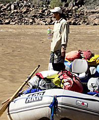
Deubendorff Rapid at mile 131.7 is near the end of the Middle Granite Gorge. I didn't get photos in there, though it's spectacular. We had lunch below Deubendorff, which was another 1997 camp.

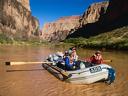
The rapid most discussed is Bedrock at mile 130.5 where almost all the discussion is about how you must run it to the right. Well, boatman Tom went right. This required his being on the right side of a wave train entering the rapid--a series of waves that leads directly to a dividing rock. Another, shorter wave train then goes to the right and you float easily out the end of the rapid.

But not all our boats got to the right. Erika entered the rapid on the wrong side of those entry waves and despite heroic effort, was taken left. We saw this from above, did our own run as Erika went around the eddy over there several times, and then watched her nose her boat into and down the channel that comes back to the right again. No problem.

Tom mentioned that at low water (like 5000 cfs) you have to go left. There's no way to get to the right side. Further, he said that if you intend to go left, it's fine. But if you accidentally go that way, you can get in trouble with a large hole over there. Such a hole is hard to imagine because I don't think there's much drop between the dividing rock and the slot, but I'll take Tom's word for it.

So, although this may be heresy, what's wrong with a left run at Bedrock? Every guidebook says no, but Erika's run looked to me like it worked out just fine. The slot back to the right may be narrow by Grand Canyon standards, but it's not narrrow for an oarboat (a motorboat would surely get stuck). I'd want to scout it in detail before I deliberately take my own raft over there. But from what I saw, it didn't look bad at all.

Comments are welcome from those who know more than I do about Bedrock.

The polished black rock of the gorge is wonderful!

Bass to Randy's Rock, Blacktail Canyon, Oct 17

In Blacktail Canyon, where there is a very visible contact between the Precambrian Vishnu Schist and the Cambrian Tapeats Sandstone. It must have been a high energy contact between the older rock and the advancing sandstone as a sea moved farther and farther. Large pebbles were broken off and remain there today, having been covered over before they had a chance to round off. These seashore pebbles are in several specific layers, as seen below.

Blacktail Canyon is on the north side of the river at mile 120. It's a wonderful little canyon very near the river. Among other things, it's just at the level where the Precambrian Vishnu Schist contacts the Tapeats Sandstone. The contact is near eye level and can't be missed. We camped here in 1997 and made a stop in 2006.

Our camp at Randy's Rock. That rock is just out of sight downstream. It's a large mass of rock in the river with several logs stranded on top. We would guess that someone named Randy had an unhappy experience upon that rock.

Note that the flatter rocks tend to be tilted downstream. This is typical of rocks along rivers. Future geologists, if they see just these rocks, will know which way the river flowed.

Wednesday, November 01, 2006

Bass Camp, Oct 16, 2006


Above and below, implements at the old Bass Camp.


Boats floating through Bass Rapid, as seen upstream from the North Bass Trail between our camp and the old Bass Camp. The trail then goes out to the North Rim.

Cactus with red blossom, foot of the North Bass Trail at our camp

Our camp at river mile 108.3, a place commonly called Bass Camp but not the same as William Bass' camp up Shinumo Creek.


We laid over at Bass and the weather was fine. Early in the trip, there would be dew on everything each morning. But now, the normal Arizona dryness was returning and we'd be fine for the rest of the trip.

On our layover day, we walked up over the hill and down into the drainage of Shinumo Creek, where William Wallace Bass had his camp. Bass had come to the canyon as a miner but had turned to guiding tourists instead. There are a number of implements where his camp used to be. These have been gathered and put in a small alcove.

Shinumo Creek felt good! In 1997 we'd gone up its mouth to a fine waterfall and pool. I'd never been to this other part of the same drainage.

Crystal Rapid, October 15, 2006

Crystal Rapid is runnable on the left at low water, and on the right at higher water. With around 8000 cfs, we were somewhere in between. Most of our guides went right, but a few went left including our one dory.

Walt went right. It was much easier to get to the right as opposed to my own two runs at 28,000 and 21,000 cfs, but much rougher once there. It's a narrower passage between the rocky right bank and those huge waves, but not that big a deal if you're in the right place.

The boats that went down the left did fine, though it looked like the problem over there was staying off the wall.

As we started, Walt called Crystal "the real deal!" That phrase would not be used again until Lava Falls.

Talking with Walt later, he helps run a Spanish language school in Costa Rica and he'd be going down there very soon after this trip. He runs a couple of Grand Canyon trips each year.