High Mountain Doings

From 8200 feet along one side of the Upper Arkansas River Valley in central Colorado, my blog is about many things: travel including river and bicycle trips, and other experiences as well. The focus is on photography, not lots of text.

Tuesday, November 25, 2008

Home from Utah

We're home from a truly wild part of SE Utah--a portion of the White Rim Trail on the Green River side of Canyonlands National Park, and also from a brief tour through Arches National Park. Photos, captions, and descriptions will soon appear here.

Thursday, November 20, 2008

Winter is Coming, Summit County

Looking west along the trail described below. I usually bicycle in this direction. It goes to the Copper Mountain Ski Area, and also beyond it to Vail Pass.

This is a paved bicycle/hiking trail that parallels Interstate 70 (but on the other side of a small creek) near Frisco in Colorado. I stopped there intending to bicycle on it, as I've done several times before, but it was snowpacked on this mid-November afternoon. So I didn't bicycle.

Labels: ,

Wednesday, November 19, 2008

Even More Random Photos

This small lake is right at the top of Independence Pass. I'm not sure why it's there. Is it a tarn? Doesn't quite match up (tarns occupy cirques, the bowl-shaped areas where glaciers once began to flow). Anyway, it's a pretty little lake, whipped by the strong winds across the pass.

This is nearly the summit of Independence Pass, crossing the mountains between the Upper Arkansas River Valley, and Aspen, Colorado. View eastward.

Labels:

Monday, November 17, 2008

More Random Photos

In Denver recently, stopped at a railroad crossing in the northern part of the city, I got out my camera and photographed the train.

A photo from a previous year, this colorful fall foliage is on Aspen Ridge east of the Upper Arkansas Valley. Mt. Princeton is across the valley, on the west side.

Labels:

Monday, November 10, 2008

Two Miscellaneous, Unrelated Photos

This is Agnes Vaille Falls, in Chalk Creek Canyon near home. We walked up there, maybe a half mile from the parking area, one afternoon.

This is the house of Patty's friend Mary. It's a second house (Mary lives in Denver as does Patty). We sometimes stay here when it's unoccupied, which makes a fine break from the ordinary. The house is not far from Bailey, Colorado, which is about two thirds of the way from here to Denver.

Labels:

Wednesday, November 05, 2008

Past Confluence, Into Cataract

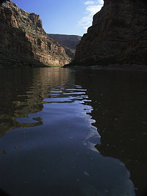
This is the former Colorado River several miles beyond the end of rapids in Cataract, destroyed by Glen Canyon Dam. Though Powell Reservoir is now low, the river is backed up by something. Downstream of Mille Crag Bend, the current goes to nearly zero. Rowing out of there is hard work, and we had no wind. It's pretty but not natural.

Big Drop III Rapid, a.k.a. Satan's Gut, where success depends upon hitting a narrow slot at the top. If you do that, the run seems almost automatic. At somewhat higher water, about 10,000 cfs or so, you run the far right. This was about 6500 cfs.

Big Drop I Rapid. This is a straightforward rapid, but the water is rough, pitching the raft around. It's mostly a matter of picking where you want to enter that first wave.

This is Capsize Rapid, or Rapid #15. The earliest rapids in Cataract are easy. This is the first challenging one, and it's not hard as long as you take one of two correct routes, missing that middle rock.

Patty on the beach at our layover camp, reading. And this is called sunburn!

Rocks along the beach at our Rapid #9 layover camp. The rapid is beyond the light colored rocks.

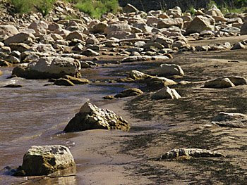
Rocks, from same place (our raft) as photo below.

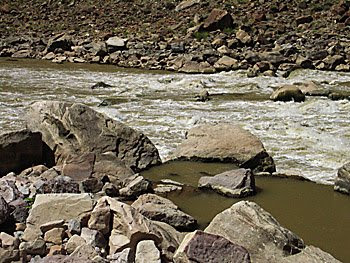
A fan of rocks below the mouth of a tributary to the Colorado River in Cataract Canyon, taken from the raft where we stopped for a few minutes.

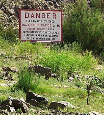
This sign and signup box are just over two miles below the confluence. Used to be on the right about two miles down, but they were moved. You need to have a Cataract river permit to be here at all, but this box is to sign up for campsites. But I think there were only two other trips in the canyon when we signed in.

Labels: ,

Saturday, November 01, 2008

More Cataract Canyon

Approaching the confluence of the two rivers, the rock layers tilt upward because the Meander Anticline runs through there. The confluence is just around the next bend from here.

Patty rowing the raft. She took to this really quickly, and was a big help. She didn't row any of the rapids, but there is a lot of flatwater on this trip. Maybe rapids next year, if she agrees!

Patty is looking for something.

Daytime reflections on the river. One side of the river shadowed and the other in the sun. Somewhere in Stillwater Canyon.


Sunset is a particularly beautiful time in Canyonlands. Not that it isn't beautiful at all times, in all seasons. This was one of our camps in Stillwater Canyon.

On down the river, which is very slow most of the 52 miles to the confluence between the Green and the Colorado Rivers. I don't know the locations of most of these photos (I did once) so I will try to post most of them by exposure number, which of course increased downstream. An exception to this is the very first photo in this section, across from Anderson Bottom.

The yellow plants on the right used to be tamarisk, hated by river runners and by water suppliers in Southern California and Arizona because of their huge water consumption, and because they took over entire riverbanks for miles. They're being consumed at long last by beetles which are being bred for the purpose.

A continuation of our Cataract Canyon trip in August of 2008. A previous post shows the beginning of this trip.

Other projects got in the way, but here are some more photos of the Green River's Stillwater Canyon. And in another post, Cataract Canyon which is after the confluence with the Colorado River. This particular rock is across the river from Anderson Bottom.

Labels: , ,